Watershed

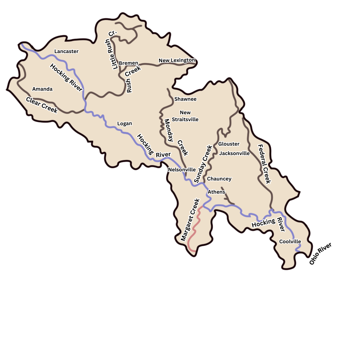
Discover the watershed’s geographical location and explore an interactive map highlighting the river’s course and surrounding areas.

Hocking River Watershed

The Hocking River is a southeastward flowing tributary of the Ohio River with its mouth at Hockingport, Ohio, about 200 miles below Pittsburgh. The watershed is roughly rectangular in shape, extending in a southeasterly direction from the headwaters in Fairfield County to the Ohio River in Athens County. The watershed has a maximum width of 26 miles and a total drainage area of 1200 square miles, and lies entirely within the Kanawha section of the Appalachian Plateau Physiographic Province. The river distance from its source to its mouth is approximately 95 miles, flowing thru the cities of Lancaster, Logan, Nelsonville, Athens, and the villages of Chauncey, Stewart and Rockbridge.

Bottomlands

The bottomlands along the Hocking River are generally flat and cultivated, and average about one-half mile in width. Most of the larger communities in the watershed are situated within the river valley, including the Cities of Lancaster, Logan, Nelsonville and Athens.

Rush Creek

Rush Creek in the upper portion of the basin is the largest tributary of the Hocking River, having a drainage area of 236 square miles. The next largest tributary is Federal Creek in the southern part of the watershed, which has a drainage area of 145 square miles. Only two other tributaries have a drainage area in excess of 100 square miles, those being Sunday Creek with a drainage area of 139 square miles and Monday Creek with 116 square miles. Clear Creek in Hocking County has a drainage area of 92 square miles and Margaret Creek has a drainage area of 60 square miles.

Dams and Reservoirs

Throughout the watershed there is a system of dams and reservoirs, which provide flood reduction, water supply, and recreational opportunities. To name a few of these with notable size or impact include Stroud’s Run (Dow Lake); Lake Logan; numerous flood retarding structures in the Rush Creek Conservancy District; Lake Snowden; four lakes in the Margaret Creek Conservancy District; and the largest artificial lake in the Hocking River basin is Burr Oak Lake (Tom Jenkins Dam), which is a USACOE project completed in 1950. Additionally there are numerous flood retarding structures, and sediment control structures constructed by the Soil Conservation Service in the Upper Hocking Watershed.

Gradient

The gradient of the river through both Athens and Hocking Counties is relatively flat, having slopes of roughly 2 feet per mile. This flat gradient is reflected in the numerous bends and meanders. Thus, floodwaters remain longer in valleys with such gentle gradients than in valleys with greater slopes.

Hocking River Watershed

This map of the Hocking River shows its 95-mile flow from Fairfield County to the Ohio River in Athens County, passing through several cities and villages. It highlights the flat bottomlands, major tributaries like Rush Creek and Federal Creek, and key dams and reservoirs for flood control, water supply, and recreation.
1

Baldwind Run

2

Buck Run

3

Butts Run

4

Clear Creek

5

Coates Run

6

Dow Lake

7

Federal Creek

8

Fivemile Creek

9

Fourmile Creek

10

Frost Run

11

Green Run

12

Hamley Run

13

Harper Run

14

Hocking River

15

Hunters Run

16

Jordan Run

17

Margaret Creek

18

Miller Run

19

Minkers Run

20

Monday Creek

21

Oldtown Creek

22

Piper Run

23

Pleasent Run

24

Ross Run

25

Rowell Run

26

Rush Run

27

Scott Creek

28

Skunk Run

29

Sugar Creek

30

Sunday Creek

31

Threemile Creek

32

Tiger Run

33

Twomile Run

34

Unnamed 1

35

Unnamed 2

36

Unnamed 3

37

Willow Creek